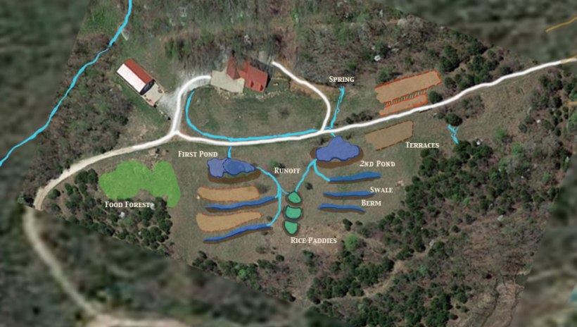
About nine years ago, when we were first dreaming about what this place could become, a permaculture consultant drew us a map. We pictured an event center where people could gather, learn and celebrate, with a community living on the land around it. The map showed how the land itself could hold that dream: where water could be caught and slowed, where food could grow, and how all the pieces could fit together.
The plan was never carried out. It still holds good ideas, though, and it’s a fine way to explain what permaculture is and how it works.
What is permaculture?
Permaculture is a way of designing land, homes and communities so they work like a healthy natural system. The word joins “permanent” and “agriculture,” and many people also hear “permanent culture” in it. Bill Mollison and David Holmgren developed the idea in Australia in the 1970s.
The heart of it is simple. Instead of fighting the land, you watch it closely first. Where does the sun fall in winter and in summer? Where does water run when it rains? Where does the wind come from? What is already growing? Then you place each piece so it helps the others. The pond waters the garden, the garden feeds the people, the people’s scraps feed the soil, and nothing goes to waste.
The zones
One of the most useful tools in permaculture is zones. Zones are rings of use that start at your door and move outward. The more often you need to visit something, the closer it goes to the house. That way you aren’t walking a quarter mile to pick a handful of parsley.
- Zone 0: The house. The center of daily life, where you cook, rest and plan.
- Zone 1: Right outside the door. The things you visit every day: kitchen herbs, salad greens, a few tomato plants, seedlings that need watching.
- Zone 2: A short walk away. Things you tend a few times a week: berry bushes, fruit trees, larger garden beds and the compost pile.
- Zone 3: The main growing area. Bigger plantings that need less frequent care, and larger water storage like ponds.
- Zone 4: Semi-wild land. Woods you visit now and then for foraging, wild greens, mushrooms and firewood.
- Zone 5: The wild. Land left alone, where we watch and learn from nature and leave room for wildlife.
Many permaculture books put chickens or grazing animals in zones 2 and 3. On a vegan homestead, those spaces go to plants, compost and pollinators instead. This is called vegan permaculture. You can learn more about it from the Vegan Organic Network.
Reading our map through the zones
The map doesn’t draw the zone rings, but you can see them in it.
- Zone 0 is the log house at the top of the map, with the big metal building just to its left.
- Zone 1 is the ground right around the house, where kitchen gardens belong.
- Zone 2 is the food forest on the west side. A food forest is a planted woodland built in layers, the way a natural forest grows: tall nut and fruit trees, smaller trees under them, then berry bushes, herbs, ground covers and vines.
- Zone 3 is the open slope below the driveway, where the consultant placed the ponds, swales, rice paddies and terraces.
- Zones 4 and 5 are the woods that wrap around the edges of the map and run beyond it.
Water first
Most of the drawing is about water, and that’s no accident. In permaculture, you start with water, because water decides what can grow everywhere else.
The spring sits just to the right of the house. On the map, its water flows down to two ponds below the driveway, along with rain running off the hill. The ponds would hold that water instead of letting it rush away.
Below the ponds, the map shows swales and berms. A swale is a shallow ditch dug dead level along the slope. The soil from the ditch is piled on the downhill side, and that mound is the berm. When rain comes down the hill, it stops in the swale and soaks slowly into the ground instead of running off and carrying the soil with it. Trees and shrubs planted on the berm drink from that stored water for weeks afterward.
The small rice paddies step down the hill between the ponds, using the overflow. The terraces on the east side are flat steps cut into the slope, so beds can sit level on ground that would otherwise be too steep to plant.
The first dream: an event center
When this map was drawn, we did not plan a farm animal sanctuary. We did want a community, but the event center came first.
The idea was that the land would do more than feed people. Visitors could walk past the ponds, through the food forest and along the swales, and see a working example of land that heals and feeds itself. Workshops could be taught right in the gardens. A community could grow from there, with many hands to plant, harvest and care for the land, and the land would give back food, water and beauty to everyone who came.
What happened instead
More ideas kept flowing. Sadly, in a way, that also scattered us. Many things happened, and the dream was not fulfilled. The big earthworks were never dug.
Later, we wanted to market the land as a site for a farm animal sanctuary. That sanctuary is still listed on Google as a business.
Meanwhile, the land grew in a different way, one garden at a time and mostly by hand: hugelkultur beds built from logs and leaves, a pile of boulders turned into a rock garden, comfrey that was planted once and came back every year after. These smaller projects follow the same ideas as the map: watch the land, work with water, build the soil and let each piece help the others.
For whoever comes next
The map is still here, and so is the land it describes. The spring still flows, and the slope below the driveway still has room for ponds, swales, a food forest and the people to enjoy them. If you’re dreaming about what this place could become, this map is a good place to start.
How we wrote this together
This article was written by Patricia, a resident of the Living Springs Log House, with Claude, an AI assistant made by Anthropic. Patricia shared the map and her memories of the early vision, and Claude explained the permaculture ideas behind it. The opinions are Patricia’s own.

